https://ia800408.us.archive.org/14/items/Manetho/Manetho.pdf
Wednesday, 25 December 2024
MANETHO ~ AEGYPTIAKA ~ FREE PDF
Wednesday, 14 April 2021
NAUCRATIS ~ THE GREEK COLONY OF EGYPT
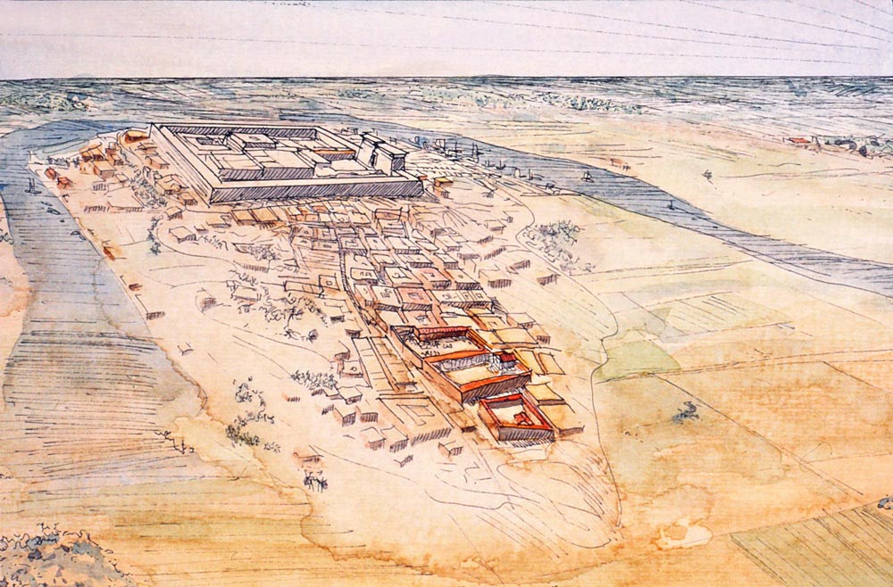
Naucratis or Naukratis (Greek: Ναύκρατις, "Naval Command" ) was a city of ancient Egypt, on the Canopic branch of the Nile river, and 72 km (45 mi) southeast of the open sea and Alexandria. It was the first and, for much of its early history, the only permanent Greek colony in Egypt; it was a symbiotic nexus for the interchange of Greek and Egyptian art and culture.
The modern villages of Kom Gi’eif, el-Nibeira and el-Niqrash cover the archaeological site, which has become a find of the highest significance and the source of not only many beautiful objects of art now gracing the museums of the world but also an important source of some of the earliest Greek writing in existence, from the inscriptions on its pottery.The sister port of Naucratis was the harbour town of Thonis/Heracleion, which was undiscovered until 2000.
Archaeological evidence suggests that the history of the ancient Greeks in Egypt dates back at least to Mycenaean times (1600–1100 BCE) and more likely even further back into the proto-Greek Minoan age. This history is strictly one of commerce as no permanent Greek settlements have been found of these cultures to date.
The first report of Greeks in 7th century BCE Egypt is a story in the Histories of Herodotus of Ionian and Carian pirates forced by storm to land on or near the Nile Delta. It relates the plight of the Saite Pharaoh Psammetichus I (Psamtik) of the 26th dynasty of Egypt, who was overthrown and sought the advice of the Oracle of Leto at Buto. The oracle cryptically advises him to enlist the aid of the "bronze men" who would "come from the sea." Inspired upon seeing the bronze armor of the shipwrecked pirates, he offers them rewards in return for their aid in his campaign of return to power. Upon the success of this endeavor, he makes good on his word and bestows on the mercenaries two parcels of land (or "camps," στρατόπεδα) on either side of the Pelusian branch of the Nile.At present these sites remain uncertain but this may be a reference to the city of Daphnae.
Naukratis was the site of an Egyptian town before the Greeks arrived, later becoming established as a military settlement occupied by mercenaries. Naukratis was located on the Canopic branch of the Nile in the western Delta some 16 km from Sais. The Canopic tributary was one of the major waterways linking the Nile valley with the Mediterranean, and the most accessible of the Nile’s tributaries during the Saite Period. The early settlement then developed into a busy trading port. They exchanged goods with the Greeks and with other Mediterranean states. Greek traders settled in Naukratis and a large Greek community began to develop.
In 570 BCE, the Pharaoh Apries (Wahibre, reigned 589–570 BCE) led the descendants of this mercenary army made up of 30,000 Carians and Ionians against a former general turned rebel by the name of Amasis. Although fighting valiantly they suffered defeat and Amasis II became Pharaoh (reigned 570–526 BC). Amasis shut down the "camps" and moved the Greek soldiers to Memphis where they were employed "to guard him against the native Egyptians."
Herodotus: "Amasis was partial to the Greeks, and among other favors which he granted them, gave to such as liked to settle in Egypt the city of Naucratis for their residence."
It's worth noting that Herodotus says "gave the city (πόλῐν)", which seems to indicate the existence (now borne out by archaeological evidence) of a "city" already there. This older city, settlement more likely, was no doubt small and inhabited by a mix of native Egyptians, Greeks and possibly even Phoenicians. Thus it seems the city was turned over to the Greeks, "chartered," in the years immediately following 570 BCE. The earlier date of c. 625 BC put forward by archaeologists may be the actual establishment of a settlement at the site.
Amasis indeed converted Naucratis into a major treaty-port and commercial link with the west. This was done most likely as a means to contain the Greeks and concentrate their activities in one place under his control. It became not the colony of any particular city-state but an emporion (trading post) similar to Al Mina, the largest market port of north Syria.
According to Herodotus, the walled shrine known as the Hellenion was a co-operative enterprise financed by 9 eastern Greek cities:
4 Ionian: Chios, Klazomenai, Teos and Phocaea
4 Dorian: Rhodes, Halicarnassus, Knidos and Phaselis
1 Aeolian: Mytilene
Miletus, Samos and Aegina had their own separate sanctuaries. Thus the natives of at least 12 Greek city-states worked in a collaboration which, not only was it rare, but also proved to be lasting.
Naucratis later became an important center of Greek culture under the Roman Empire, producing several celebrated orators of the Second Sophistic in the 2nd and early 3rd centuries CE. The 3rd century writer Athenaeus came from Naucratis.
The site of Naucratis was discovered by Flinders Petrie who dug there in 1884–1885. He was followed by Ernest Arthur Gardner and finally David George Hogarth, in 1899 and 1903.
The archaeological focus fell into two areas of northern and southern quarters. Found farthest south was a large Egyptian storehouse or treasury and just north of that a Greek mud-brick Temple of Aphrodite roughly 14 m × 8 m (curiously not mentioned in Herodotus' list.) Directly east of this temple a small factory for faience scarab seals has been found.
In the northern section several temple ruins have been found- Temple of Hera, Temple of Apollo and Temple of Dioscuri, including what may be Herodotus' Hellenion discovered by Hogarth in 1899 . "None of the votive pottery found here need have arrived earlier than the reign of Amasis, so it may well be that the Hellenion was founded as the result of his reorganization of the status of Naucratis, while the independent sanctuaries ... are of the earlier years of the town."
More recently, American archaeologists W. Coulson and A. Leonard founded "The Naucratis Project" in 1977 carrying out surveys in 1977–1978 and further surveys and excavations to the south of the site from 1980–1982 (under the auspices of the American Research Center in Egypt). Unfortunately, they found the original northern sanctuary section submerged under a lake formed by the risen water table and roughly 15 m deep.
This part of the site remains under water today, making further work there difficult if not impossible. Their assessment of the approach taken and methods used by their predecessors was less than complimentary. According to Leonard and Coulson, the first excavations focused on the religious building,neglecting the trading and domestic sites. Moreover, little to no research has been done on the later Hellenistic and Roman aspects of the site.To make matters more challenging, a significant part of Naucratis had been dug in Patrie's time by the local farmers, in order to use the soil as fertilizer.
The barrier of the high water table made it impossible for them to find anything older than the Ptolemaic era. They agreed with Hogarth that the "great temenos" of Petrie was actually an Egyptian building and that indeed the entire south section of the town appeared to be non-Greek. Overall most of the finds were vases (some whole, most fragmentary) used as votives in the temples, but also stone statuettes and scarab seals. These are scattered to museums and collections around the world, the earlier material largely brought to Britain (mostly in the British Museum) and the latter to the Graeco-Roman Museum in Alexandria.
The Egyptians supplied the Greeks with mostly grain but also linen and papyrus while the Greeks bartered mostly silver but also timber, olive oil and wine. Naukratis, and the associated Greek "forts" in the general delta area, as demonstrated by accounts given above, became a ready source of mercenary fighting men for the Saite pharaohs, men with superior hoplite armor and tactics, also possessing invaluable naval expertise.
Naucratis soon became a profound source of inspiration to the Greeks by re-exposing them to the wonders of Egyptian architecture and sculpture lost to them since the Bronze Age. Egyptian artifacts soon began their flow along the Greek trade routes finding their way into the homes and workshops of the Ionian Greek world and, via Aegina, the city-states of mainland Greece.
Naucratis was not only the first Greek settlement in Egypt but also Egypt's most important harbor in antiquity until the rise of Alexandria and the shifting of the Nile led to its decline. Nevertheless, the ancient city of Heracleion/Thonis also rivalled Naucratis as an important port city of Egypt, especially from the 6th to the 4th century BCE.
Edited from: Wikipedia
Tuesday, 22 December 2020
BRONZE COINS OF THE PTOLEMAIC EGYPT
During the reign of the Greek Ptolemaic kings and queens, Egypt produced substantial coinage. There are numerous designs in all kinds of metals, mint-designations and varieties that make the series both challenging and fascinating.
We’ll start with an 11 mm bronze of the founder of the dynasty, Ptolemy I, who ruled from 323-305/4 BCE as satrap and from 305/4-282 BCE as king. It was struck at the chief mint of Alexandria sometime from c.311 to 306 BCE, shortly before he declared himself king.
Not surprisingly, it features the portrait of his deified predecessor, Alexander III ‘the Great’ (336-323 BCE). It is paired with an eagle on a thunderbolt, a design which served as the ‘dynastic badge’ of the Ptolemies. It’s worth noting that the reverse bears the name of Alexander rather than Ptolemy.
Although stylistically different than the previous coin, this 17 mm bronze issued c.306-294 BCE at the Alexandria mint, most likely was issued after Ptolemy I had assumed the title of king. It has the same principal types of the previous coin, yet the reverse now names Ptolemy rather than Alexander.
This 20 mm bronze of Ptolemy I, struck at Alexandria after c.294 BCE, features a portrait of Alexander III wearing an elephant scalp. The reverse features the badge of Ptolemy.
This lovely 16 mm bronze of Ptolemy I was struck at Paphos on the island of Cyprus. Showing the bust of the goddess Aphrodite and the Ptolemaic eagle-badge, it was struck after c.294 BCE.
Issued at the same time and at the same Cypriot mint as the previous coin, this 22 mm bronze features an entirely different vision of Aphrodite, who’s crowned with an ornamented polos.
We now move on to Ptolemy II (285/4-246 BCE), the son and successor of Ptolemy I. This 23 mm bronze of Ptolemy II, struck at Alexandria sometime after about 265 BCE, looks much like the types introduced by his father some three decades before, as it features a portrait of Alexander III in an elephant scalp and the badge of the Ptolemaic dynasty.
Also struck for Ptolemy II is the 40 mm bronze, above, which belongs to a very large series the king initiated in about 265 BCE or soon afterward. It bears what would become the iconic obverse design for Ptolemaic bronzes: the head of the syncretic god Zeus-Ammon, adorned with a diadem and ram’s horn. In this case, he also has at the top of the diadem a design element that is believed to be a stylized crown of Ammon.
The reverse features two Ptolemaic eagles standing on thunderbolts, side by side. Though in some later cases two eagles indicate the joint-rule of two monarchs, at this time, Ptolemy II was the only reigning king, so we must presume they represent both the king and Zeus-Ammon.
Interestingly, this coin also bears another ‘trademark’ feature of most Ptolemaic bronzes struck from this point onward: a central cavity on both the obverse and reverse. Often, there are also strong traces of incised lines radiating outward from the center in a circular fashion. Both are diagnostic of their production rather than circulation damage.
It has been suggested that these new production features are tied to a monetary reform of the 260s BCE in which earlier Ptolemaic bronzes were demonetized. This may have been linked to larger economic reforms that modified the Egyptian tax system.
This 31 mm bronze of Ptolemy II from c.265 BCE or later bears the laureate head of Zeus and the badge of the Ptolemaic dynasty. Unlike the Ptolemaic bronzes we’ve seen thus far, it was not issued in Egypt, but at Ake-Ptolemais in Phoenicia, a prosperous region that in the Hellenistic era was hotly contested between the Ptolemies and their neighbor-kings, the Seleucids.
The two bronzes above, which range from 26 mm to 27 mm in diameter, also were not struck in Egypt. Indeed, they are believed to have been struck in about 264/3 BCE in Sicily on behalf of Ptolemy II. Like the coin from Ake-Ptolemais, they bear the laureate head of Zeus and the Ptolemaic badge.
We continue our survey of Ptolemy II’s bronzes with this 21 mm coin struck in Cyrene, a region of North Africa to the west of Egypt. It was struck c.270-261 BCE by that region’s ruler, Magas. It features the head of Ptolemy I and the thunderbolt of Zeus, above which the name of King Magas appears in the form of a monogram.
Ptolemy II also struck the above piece, a 10 mm bronze depicting his sister-wife Queen Arsinoe II (died 270/68 BCE). With a standing eagle on its reverse, it is attributed to the mint of Byzantium, where the continents of Asia and Europe meet.
We now transition to the issues of King Ptolemy III (246-222 BCE), the son of Ptolemy II and grandson of Ptolemy I. Above are two large and heavy coins of 33 mm to 35 mm from the Alexandria mint with the familiar Zeus-Ammon/Ptolemaic badge designs.
The 30 mm bronze of Ptolemy III, above, has the same types as the previous two coins. However, it was struck at the Phoenician mint of Tyre, as indicated by the club before the eagle.
Another common type of Ptolemy III is illustrated by the two specimens above, which offer a variation of the normal reverse with the eagles looking back toward a cornucopia set at their shoulders. They are from the Alexandria mint and are large pieces ranging from 37 mm to 39 mm in diameter.
An unusual reverse type for the Zeus-Ammon bronzes of Ptolemy III appears on the 16 mm coin, above. It was struck at Paphos on the island of Cyprus and shows a statue of the goddess Aphrodite.
We’ll round out our survey of the bronzes of Ptolemy III with those bearing portraits of living (or once-living) rulers rather than Zeus-Ammon. Shown above is a 12 mm coin that resurrects a type used by his father and grandfather, which pairs the head of Alexander III wearing an elephant scalp with the Ptolemaic badge.
The dynasty founder Ptolemy I is honored on the 22 mm and 26 mm bronzes shown above. The founder’s portrait is paired with the head of Libya, as these coins were struck in neighboring Cyrene, where she was recognized as the personification of the region.
Similarly interesting are the 19 mm and 20 mm bronzes above, which bear the distinctive portrait of Ptolemy III and the Ptolemaic badge. These issues are attributed to the mint of Corinth in Central Greece, where the Ptolemies had military interests.
A decidedly different portrait, also thought to represent Ptolemy III, occurs on this rare 16 mm bronze from the Ionian city of Lebedus, which at this time had been renamed Ptolemais. The reverse depicts the standing figure of Athena.
Our last bronzes of Ptolemy III bear portraits of his wife Berenice II, the daughter of Magas who ruled neighboring Cyrene. She died in 221 BCE, not long after her husband. The first of our three examples, the rare 16 mm bronze above, is attributed to the mint of Lebedus (Ptolemais).
Another portrait of Berenice II appears on this 25 mm bronze struck by her husband at a mint in northern Syria. Its reverse shows a filleted cornucopia and bears an eagle countermark.
The Berenice II portrait bronze above, also issued by Ptolemy III at a mint in northern Syria, has a different reverse type, the iconic Ptolemaic badge.
This article is concluded with two issues of Ptolemy IV (222-205/4 BCE), the son of Ptolemy III and Berenice II. The first, a coin struck at the Alexandria mint, has the familiar Zeus-Ammon/Ptolemaic badge designs and is a large piece, being more than 40 mm in diameter and tipping the scale at more than 68 grams.
From the same issue is this 33 mm bronze of Ptolemy IV. Though (as noted earlier) the central cavities were part of the manufacturing process of most Ptolemaic bronzes struck after c.265/0 BCE, the ones on this example are especially pronounced.
Thursday, 9 April 2020
LIST OF THE ANCIENT CITIES CALLED 'ALEXANDRIA '
In a span of just 13 years, from 336 BCE to 323 BCE, Alexander the Great pushed the boundaries of his Macedonian Kingdom as far south as Egypt and as far east as India. Along with conquering region after region, people after people, he founded a series of cities which he named for himself. These cities would generally serve as places to settle the many thousands of veteran soldiers who had followed him across the Middle East and into South Asia. Many of these Alexandrias persist today: some with different names; some retaining versions of their original name. Other Alexandrias have long since passed, and still others have been lost to history. According to the great biographer/philosopher Plutarch, Alexander founded at least 70 cities, although this number probably include pre-existing settlements renamed and/or repopulated by Alexander. The actual number of cities directly founded by Alexander regardless is known to be at least twenty, and most of those took his name. Below, a summary of the various Alexandrias (and other such derivative toponyms) in chronological order.
Founded in 340 BCE, while Alexander was still a crown prince under his father Philip II. Little else is known about this presumably short-lived settlement other than its location was likely near the modern Bulgarian city of Sandanski in the extreme southwest of the country.
Alexandria by the Latmus: This is likely the ancient fortress city of Alinda, in the modern-day Aydın Province of Turkey, which dated back hundreds of years before Alexander. Apparently refounded as a military settlement in 333 BCE, the city was returned to its previous name sometime before 81 BCE. Coins were still being minted here into the 3rd century CE.
Now known by its Turkish endonym İskenderun -although the modern city may just preserve the name of the ancient city rather than being a direct continuation-the city was founded on the Mediterranean coast in 333 BCE at the north entrance to Syria. Alexandretta prospered until the 3rd century CE, when it was surpassed by neighbouring Antioch (Antakya).
Easily the most famous of all Alexandrias and one that remains a major metropolis today of well over 4 million people, Alexandria, Egypt was founded in 331 BCE by Alexander to be the new centre of Hellenism in Egypt.
The new city was built on the site of the pre-existing city of Rhacotis; within a century, it was the largest city in the world. Despite the various rulers that have come and gone throughout the millennia (the Ptolemies, the Romans, the Sassanids, the Ottomans, the British, and the current republic of Egypt), Alexandria has maintained its prominence as the second city of Egypt after Cairo.
Conquered by the Parthians in 167 CE, the name Heratwas derived over time from Aria.
This is Kandahar, the second-largest city in Afghanistan. Prior to Alexander’s arrival at the end of 330 BCE, this was likely the Achaemenid city of Kapisakaniš. Arachosia was another satrap roughly equivalent to today’s Kandahar and Helmand provinces. The name ‘Kandahar’ itself derives from ‘Alexandria’ (Iskandariya). Despite its location near the edge of the empire, the city remained culturally Greek for some time after Alexander’s death. Today, Kandahar is known primarily as one of the major battlegrounds of the War in Afghanistan.
Not to be confused with the Caucasus region on the Europe/Asia border, Caucasus Indicus was an ancient exonym for the Hindu Kush. This Alexandria was a 329 BCE refounding of the Achaemenid city of Kapisa to serve as Alexander’s base in the Hindu Kush (the location is 65 km north of modern Kabul). The city would eventually be traded to the Indian king Chandragupta Maurya in 303 BCE by Alexander’s successors in exchange for 500 elephants.
Moving to the south across the region of Sogdiana, Alexander refounded a Persian city on the Oxus (Amu Darya) river in 329 BCE. For two centuries the city served as an outpost of Greek culture until its sacking by nomadic tribes in 145 BCE lead to its abandonment. Today, it is known under the Uzbek name Ai-Khanoum (‘lady moon’ or ‘face in the moon’) on the Afghan side of the Oxus across from Tajikistan. Between 1964 and 1978, Ai-Khanoum was excavated by French archaeologists, uncovering large amounts of Greek and Indian artefacts, as well as the ruins of a 5,000-seat theatre, numerous temples, and colonnaded courts. Sadly, three-plus decades of warfare have devastated the archaeological site.
Whether or not it was Alexander himself who refounded the city in 328/327 BCE or his general Craterus, the city was temporarily renamed for him regardless. A major cultural and religious crossroads, Merv is reputed to have been the largest city in the world in the mid-12th century with a population of 200,000, about twice that of modern-day Mary. The only time the site was not settled occurred in the 19th century after the Bukharans razed Merv in 1794, deported the population, and environmentally wasted the city via dam breakages.
By K. KuschSource: Brewminate
Friday, 6 March 2020
ERATOSTHENES OF CYRENE
Eratosthenes of Cyrene (c. 276 BCE–192 or 194 BCE) was an ancient Greek mathematician, poet, and astronomer who is known as the father of geography. Eratosthenes was the first person to use the word "Geography" and other geographical terms that are still in use today, and his efforts to calculate the circumference of the Earth and the distance from the Earth to the Sun paved the way for our modern understanding of the cosmos. Among his other many accomplishments were the creation of the first map of the world and the invention of an algorithm known as the sieve of Eratosthenes, which is used to identify prime numbers.
Eratosthenes was born around 276 BCE in a Greek colony in Cyrene, a territory located in present-day Libya. He was educated at the academies of Athens and in 245 BCE, after earning attention for his skills, he was invited by Pharaoh Ptolemy III to run the Great Library at Alexandria in Egypt. This was a major opportunity, and Eratosthenes was excited to accept the position.
In addition to being a mathematician and geographer, Eratosthenes was also a very gifted philosopher, poet, astronomer, and music theorist. He made several significant contributions to science, including the discovery that a year is slightly longer than 365 days, requiring an extra day—or leap day—be added to the calendar every four years to keep it consistent.
The first book of "Geography" contained a summary of existing geographical work and Eratosthenes' speculations about the nature of the planet Earth. He believed it was a fixed globe whose changes only took place on the surface. The second book of "Geography" described the mathematical calculations he had used to determine the circumference of the Earth. The third contained a map of the world in which the land was divided into different countries; it is one of the earliest examples of political geography.
After hearing about a deep well at Syene (near the Tropic of Cancer and modern-day Aswan) where sunlight only struck the bottom of the well on the summer solstice, Eratosthenes worked out a method by which he could calculate the circumference of the Earth using basic geometry. Knowing that the Earth was a sphere, he needed only two critical measurements to calculate the circumference. Eratosthenes already knew the approximate distance between Syene and Alexandria, as measured by camel-powered trade caravans. He then measured the angle of the shadow in Alexandria on the solstice. By taking the angle of the shadow (7.2 degrees) and dividing it into the 360 degrees of a circle (360 divided by 7.2 yields 50), Eratosthenes could then multiply the distance between Alexandria and Syene by the result to determine the circumference of the Earth.
Remarkably, Eratosthenes determined the circumference to be 25,000 miles, just 99 miles over the actual circumference at the equator (24,901 miles). Although Eratosthenes made a few mathematical errors in his calculations, they canceled each other out and yielded an amazingly accurate answer that still causes scientists to marvel.
A few decades later, the Greek geographer Posidonius insisted that Eratosthenes' circumference was too large. He calculated the circumference on his own and obtained a figure of 18,000 miles—about 7,000 miles too short. During the Middle Ages, most scholars accepted Eratosthenes' circumference, though Christopher Columbus used Posidonius' measurement to convince his supporters that he could quickly reach Asia by sailing west from Europe. As we now know, this was a critical error on Columbus' part. Had he used Eratosthenes' figure instead, Columbus would have known he was not yet in Asia when he landed in the New World.
https://www.thoughtco.com/
-
Bronze Corinthian helmet found in 5th century BCE burial mound in Taman Peninsula, Russia. Source: Institute of Archaeology of Russi...
-
One of Greece’s Ancient Missing Link Found: An Inquiry into Ethnic Identity, Ideology and Historical Revisionism among Contemporary Pash...
-
This very interesting Google map includes a lot of major Ancient Greek archaeological sites in various countries and it is regularly updated...
-
The Battle at the Gravia Inn (Greek: Μάχη στο Χάνι της Γραβιάς) took place in May 8th, 1821 and was fought between Greek revolutionaries...
-
The Ancient Greeks called the weekdays ' Days of the Gods.' They named each day after the Sun ,the Moon, and five of the Gods. Roma...
-
During excavations in the Hellenistic city of Ai- Khanoum, French archaeologists discovered a giant marble foot in the main temple, carv...
-
Alexander the Great and his army began a massive military campaign in 334 BCE, which resulted in Macedonians establishing many Greek citi...
-
Greek clothes, instruments and wine amphorae. Indo-Greek banquet depicted in Hadda. Haḍḍa is a Greco-Buddhist archeological site ...
-
The God Dionysos was the first to campaign to India 6451 years before alexander 154 king before androcotos ( also known as Chandragupta)...
-
The mark of the Indo-Greek kingdoms on Buddhism , is well known. From King Menander , who protected and promoted Buddhism, to the art o...